
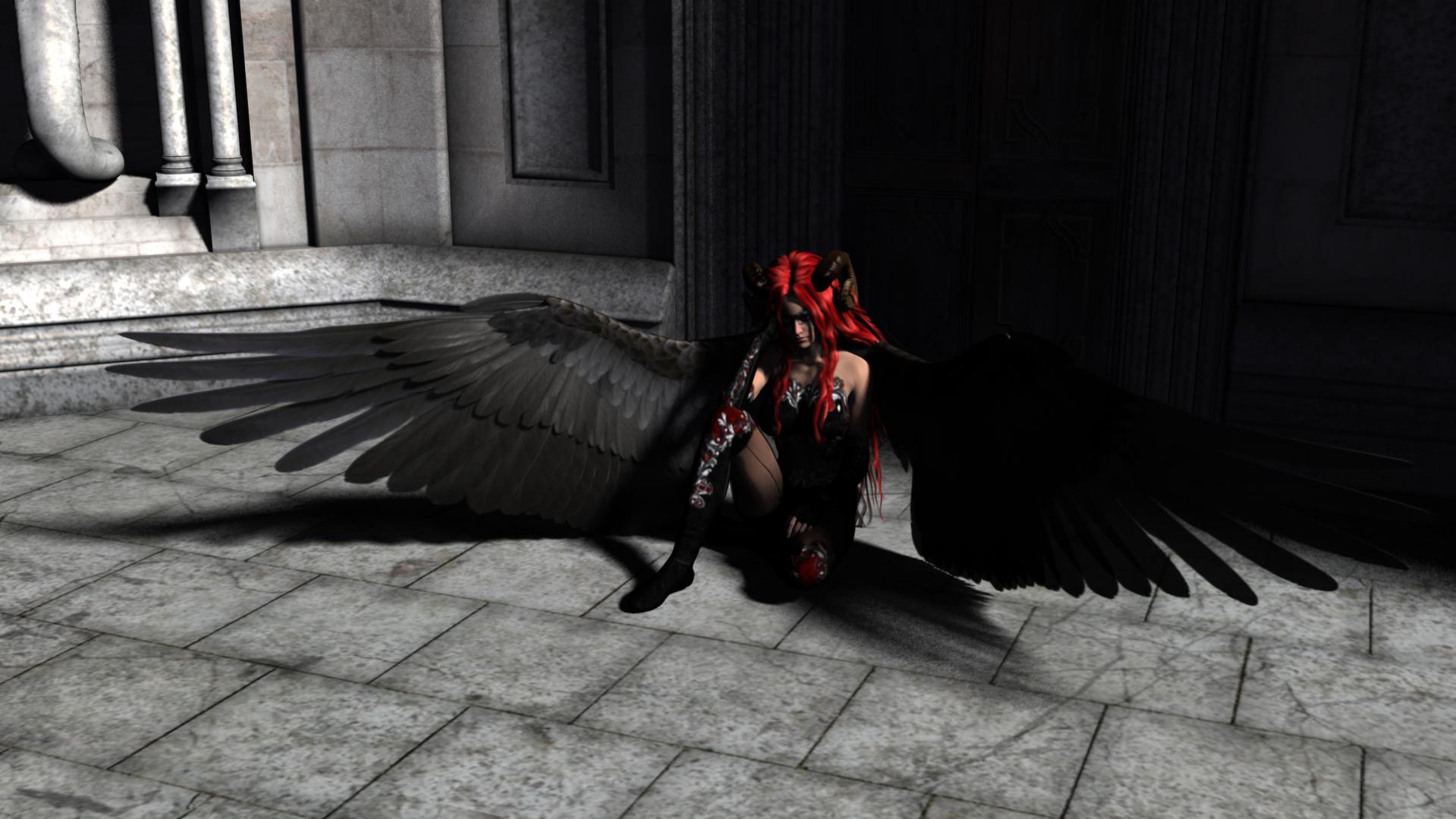
 It is easy to find someone complaining that they had countless ideas for designing worlds, only for every project to be abandoned halfway. I understand: if it is not a job, there are no working hours, and you are doing it for yourself, you continue as long as it is fun. At that point, the world usually is not finished, even if you have run a few adventures in it. The question is how to get beyond that stage. Look right and you will see a slightly flawed picture. At this size, there is no problem. Hover over it, then click. Yes, the flaw is at the horns. Far from perfect, but it shows that you can easily give your creativity room, have fun, and learn even after the world's foundations are established. Illustrations, maps, many stories, and creative use of existing elements will keep you occupied for a long time. Some fiddly, not particularly creative work can be partly automated—copying and pasting map sections, for instance—or entirely automated, through planet generators, filler events, and so on. You simply need tools. Many tasks likewise need tools to be done more efficiently.
It is worth spending a little time on tools, then. We will discuss Campaign Cartographer and its add-ons, AstroSynthesis, Fractal Terrains, DAZ Studio, Carrara, and even a little Visual Studio Community Edition. Two programs on the list are free; the others vary considerably in price. Some cost about as much as a roleplaying supplement, while others can cost as much as a substantial collector's edition. Add-ons and separately purchased content contribute greatly to the cost too. Unfortunately, this is not a cheap hobby. At least at first glance. At second glance, it occurs to us that what we can make with these tools no longer needs buying, and we may even earn money. This article will chiefly be a collection of ideas showing how simple many tools are to use. It contains specific tips and lessons, and demonstrates a few steps of progress, but is not intended as a step-by-step tutorial. That will come later, in a related section.
A picture—or map—is worth a thousand words... Or, Campaign Cartographer 3
What should we use to make maps? Some swear by Photoshop or Illustrator, but those were not necessarily designed for this. Campaign Cartographer was designed precisely for it, and its creator intends it as a complete solution. Terrain maps, political maps, treasure maps, floor plans, mazes, paper models, even stand-up paper figures all have solutions—once you start buying add-ons. Buying supplements is familiar to roleplayers, and an add-on here need not cost more than something for D&D, with considerably fewer available. But the full package's price is initially shocking, even discounted. Buying annuals and add-ons over the years was realistic; paying the discounted 180,000 forints for twenty-six products all at once is a bit much. Drop one or two products and you no longer calculate from the best discounted prices; at full price the package could be around 280,000 forints.
Viewed from another angle, things look very different. It is easiest to abandon world design when no readily achievable task sits in front of us, or something seems hard to do. Unless we are excellent artists familiar with fantasy cartography, producing the necessary maps seems nearly impossible without suitable tools. Getting a map done quickly changes that near-impossible situation. Not only the world map, but maps of individual countries, counties within them, cities, and adventure locations become easy. Instead of the demotivating “nothing will ever come of this world,” you have excellent opportunities to create. A particularly successful map brings positive feedback and a sense of achievement that help through the hardest days. Some maps can even become the basis of a board game or mobile game.
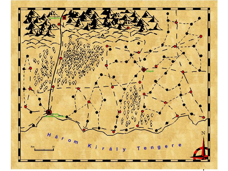 What professionals can achieve is not the important thing. Everyone can see the creators' work. It is easy to note that they demonstrate the program's capabilities, starting from what looks really good rather than what an imagined adventure location would be like. They can devote disproportionate time to it, know what they are doing, and can even supply a “missing symbol,” so for them “what symbols are in the program?” and “what symbols do we need?” are no different. The question is what you can achieve when you want to put something on the table with a new tool in limited time. Follow the basic advice: draw the coast and so on first, then work from the top left toward the right and downward, placing symbols so it does not look too ugly... Draw the roads, perhaps rivers, at the end, scatter a few labels, and you have a foundation.
I too tried choosing a new, not particularly mature version unfamiliar to me, and a style released for it a few days earlier. With zero experience, when the font setting did not work after a few attempts, I left it. The map may not be pretty or good, but it is enough to show where a route can go at the adventure location. Of course we can discuss everything that would be better. What would be better if... Many say I already went wrong choosing an unfamiliar style for its “parchment background,” one that would not be striking even if I knew it, and many things could look prettier. They usually do, but that was not yet the goal here. A few mistakes were deliberate.
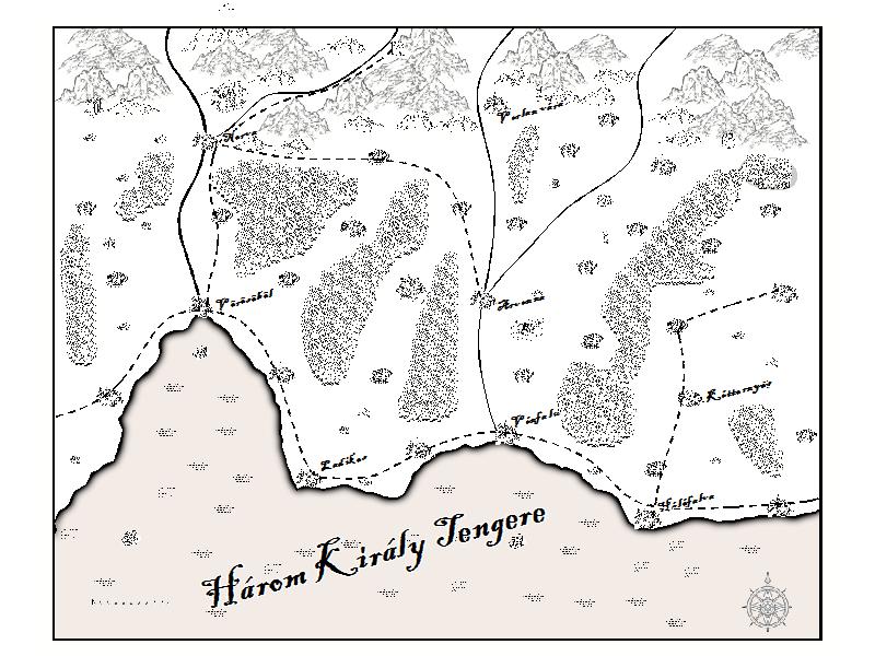 I would point out, though, that most of us are not professional cartographers and like trying new things. Even if a new tool, unfamiliar style, and little time all constrain us, perhaps combined with some lack of talent, we can still include the map with a simpler adventure. Then, of course, every important location may need a name, and labels must be sorted out. Look closely and the map on the right may be better in a few respects. The city symbols help, as does using drawing tools rather than manually scattered symbols as the main tool for forests. If we do not insist on a simple, somewhat old-school black-and-white appearance that is cheap to print, the visual result changes completely again. But why did I choose two different designs here? Honestly, it was no accident.
A parchment-textured background is a lousy choice in roughly five situations. In printing, it wastes enormous amounts of ink and adds little for the player. A white background, by contrast, would be transparent when printed. Many papers are neither completely white nor entirely smooth to the touch and could provide a better experience, more cheaply too, since we would not waste so much ink. Second, even the symbol set of this basically black-and-white design includes red dots and relies on color. Black-and-white printing really matters when we print somewhere other than home and perhaps pay to print at a larger size.
It is also poor when the map is meant to share a background with other text. Even screen display improves if we replace white with transparency and the black-to-white gradient with an opaque-to-transparent gradient. Some say it can become a layer mask in GIMP; others swear by different tricks. The fact is that the background can then be changed flexibly and may look better. This matters equally when printing on transparency film, which has plenty of advantages. A solid background texture nullifies that transparency, though a map of cities, roads, and so on could be laid over a terrain map.
That also helps if we want to place the map within another image, such as a 3D render. But let us move on. Sometimes it is useful to join maps of neighboring regions. An unnecessary background is no good there either. And in exchange for the parchment texture, that style's drawing tools are unusable at many scales. In the black-and-white map, a mountain sticks beyond the mask and many labels are missing, but it could quickly become playable. That too is a ten-minute basic effort using something new for the first time. Put a few illustrations on the map, draw on creative ideas, spend a little more time on it. Drawing tools and color could make a map even more striking. Copy and paste and symbols and fill patterns from other styles often help. A color map without too much empty space can be striking too, as can illustrations brought in from elsewhere. The store of ideas is limitless.
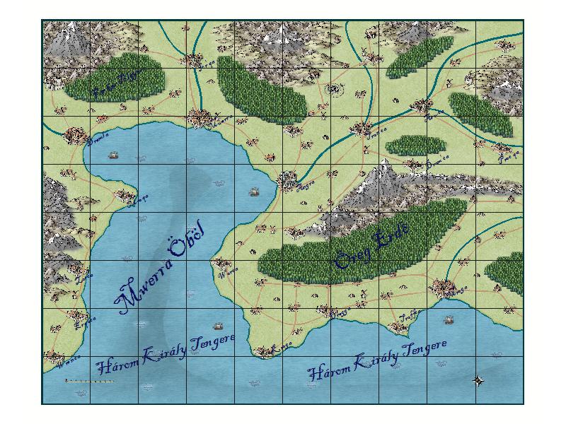 The feeling that the world will never be finished quickly gives way to having more usable maps and a better setting description than quite a few officially published games. With practice, better, prettier maps follow, given a little more time. Collect these in a wiki, documents, or forum, and gradually we see that merely gathering them together gives us a playable setting. A colorful, detailed poster-sized map is often enough for players to acknowledge that too. Naturally, we can go further and improve in many ways; the simple examples above demonstrate it. The possibilities are unlimited. The parchment-background map—the weakest—required a recent Cartographer's Annual issue, whereas the other two were made with Campaign Cartographer 3+ alone and its two basic styles. With no substantial knowledge, the simplest drawing tools, and two sentences of “knowledge” about placing symbols. You can probably make something prettier and better.
But you ask why you would buy a program just for world design. As a game master, City Designer 3 and Dungeon Designer 3 can help. City design often has problems: automatic house placement creates a slightly suburban feel because buildings are not placed tightly together. Sometimes it unfortunately places several houses on top of each other, requiring correction. There are several ways to answer this. We can find a good explanation consistent with the world for more spacious building. That is the law: after many fires, numerous kingdoms prohibited houses from touching. Or the gods prefer it... Or cities are frequently rebuilt after disasters and can still be spacious because there is enough room yet. Or we can decide we have time to place houses manually with the appropriate drawing tool to fill gaps. Or draw many kinds of city block this way in advance, then copy them together as the basis of the map.
Maps of dungeons, buildings, ships, and so on can also be made. Yes, in science fiction we can make things for systems and spacecraft too. The program understands square and hex grids, aligns symbols, and builds walls from connecting symbols, though drawing tools can do the latter too, as with castle towers. Alignment rules and symbol- and template-based operation also make paper figures easy to assemble. If symbols for body parts and the corresponding portions of armor, clothing, and so on align, a picture is quickly finished. Fine, it is not much prettier or freer than Hero Machine, but it exists. If that is insufficient, any PNG file can become a symbol. These also fit paper-figure templates, and monster and other symbols are available, so you can quickly have plenty of paper figures and then make paper models too. Many tools can be selected and purchased for the program.
Automated mapmaking: Fractal Terrains, AstroSynthesis, and other tools
Our article about the toolset would not be complete without mentioning that AstroSynthesis assembles a star map of an entire sector with one click, including typical routes, planetary populations, and planetary maps... It also calls Fractal Terrains when needed. The latter produces a planet's terrain and climate maps almost at a click according to chosen parameters. We can edit these and save them in Campaign Cartographer 3 format, where further editing is possible. Since maps can often cover smaller or larger sections, we can copy many details into another map. Drawing borders along rivers and mountain ranges, placing cities where they look suitable, adding roads, and so on quickly produces political and economic maps too.
Generated but editable data is a very useful basic tool. Generation brings many tools and tricks to mind: City Designer 3's random city and street tools, for example, or its one-click creation of maps containing the exterior walls for floor plans, leaving only their interiors to fill. We quickly realize automation puts a playable, usable foundation that can be prettified within realistic reach. But a Fractal Terrains map can also be a texture wrapped around a sphere... Make a political map version using the same projection, which is not difficult either, and interesting possibilities appear. With black-and-white or genuinely colored solutions, I also thought of importing them into a 3D program as textures or, in some cases, displacement maps. Yes, that makes a 3D landscape, or a globe, terrain model, and so on within a rendered scene. Generated data can be used creatively too. “Oh no, I need another one” no longer means mere fiddling. This can restore momentum.
A generated terrain map is professional work; the computer does its job well. Political and economic maps drawn over it can look striking in many styles, even if somewhat incomplete. Players will not necessarily notice your mistakes. They will notice that the important landmarks and borders agree across your maps. More than one published roleplaying game failed even at that. You, however, can dazzle players and GMs with many maps showing the same thing from several perspectives, including historical maps. Even if they know a map was generated and can reproduce it, they still receive something playable that may outperform the solutions of several other games. Suppose they know Fractal Terrains and also use important copy-and-paste techniques on maps. Generated maps are familiar to them. But do they use every trick? If Campaign Cartographer has a heraldry designer, adding coats of arms to a political map is no problem. Monsters assembled in Character Artist can appear on them, as can symbols intended for political and economic maps. Put a coat of arms onto a coin's displacement map, however, and we can render images of our world's coins. We are not modeling, merely replacing portions of a few displacement maps. Coin inscriptions can often be made with a “text along a curve” tool too. Likewise, a picture rendered to look like a drawing can decorate a map, or we can make a unique frame around it, reusable in many places.
A generated map is often a “cheap trick.” Many maps genuinely made in minutes are playable and better than those in quite a few published games, but someone who knows the tools could easily say, “I can do that too; others make prettier ones.” The trick comes when you surprise them. Obviously, I cannot give a perfect answer to “How do you surprise them?” Once I describe the trick and they know it, it no longer surprises. But if they do not read this article and you follow the tip, it may work. How?
Along come mythology, history, cities, schools, and many other details. Yes: the other details matter because lists of skills taught and required by schools are sometimes largely copy and paste, and much historical data can be generated too. The “BASIC language anyone can easily learn” may remind you of Visual Studio Community Edition and Visual Basic within it. If history has been generated by “dice rolls” before, that can be improved and a new version made by computer. A basic history assembled by computer from dice rolls is not much, though for a long time quite a few games had less. But historical maps for major events, easy to assemble, and a few illustrations quickly enliven it. Famous NPCs can follow, with illustrations and character sheets made for them too. Proceed this way, with room also needed for the system in your core rulebook, and it does not take a year. The foundation can be ready in three or four months, followed by testing. During that, the first publishable adventures can arrive and you can begin laying the foundations for the first supplements.
Nobody says this should be all there is. You create the interesting turning points that shape the world yourself. But the computer helps produce rulers, minor skirmishes, less important epidemics, astronomical events, and so on. Dates and discoverers can easily be assigned to quite a few discoveries and natural laws too. Use the computer where that serves a purpose; otherwise tie them to the “generated event.” Some generated rulers can receive pictures, and their campaigns can have maps. You can make a world where more than the last twenty years and their adventures matter, where several historical periods are playable, and written history forms the basis of ancient or less ancient feuds and adventures, gives ruins a history, and so on.
Many use name generators. If a generator creates inn names and guidance such as “a larger, more expensive inn in a wealthy district, at the intersection of two major routes,” placing its symbol appropriately is easy. A system could calculate approximately where and how many cities should exist, and alongside a city's name specify the symbol to use, economic symbols to scatter around it, and whether to place it near mountains, a river, or elsewhere. The foundation comes easily. Although you may decide to depart from it in a few respects, fiddly work, name generation, and city calculations accounting for many economic considerations can be automated well.
Maps and pictures: two new tools take the stage, DAZ Studio and Carrara...
A village map makes it easy to see what buildings are where. A city is possible too, but takes more work—far more, because it has more buildings. Drag a building model wherever the map has a house. Ready-made models, textures, and so on exist for roads and many other details. The point is for the models and map styles to match, so someone seeing both recognizes the same place. Yes, you can use many basic modeling tools, import ruins, and add many small objects to streets. If the free DAZ Studio is not enough and you use Carrara, that includes a complete modeling toolset.
The view can be completed. Use Carrara's fire tool, add fleeing people and a dragon, get the lighting and atmosphere right, and make the image a little painterly in postproduction, and you already have an interesting picture. I have had the pleasure of finding textured printer paper, a Canon fine-art-paper product; printing such an image on it can be particularly striking. But seeing the same place as a view, on a map, in an event description, and then as a ruined adventure location after its “historical” map will probably impress most players with your thoroughness anyway. The data already produced can so often become an adventure location, the basis of a good story, or something else to show players or a wider audience. Illustrations matter at least as much as text here. But let us discuss further possibilities too.
I know: this takes many models, a substantial collection. You can gather the free adjustable models and occasionally grab one- or two-dollar offers; that builds the quantity needed for variety. Quality unfortunately costs more. But you will have illustrations, stories, and descriptions, which your players can sometimes add to by focusing on their characters' estates. Five to ten pages a week can even be a relaxed pace. I could say that finishes things in about a year, then you can replace weaker sections over two or three weeks and have a good result. But it is not that simple. World creation will never become boring and mechanical, and output may suddenly accelerate. Some ideas demand to be born quickly. Learn a tool and you may get an idea you want to realize with it because “it fits an imagined world perfectly.” Often an add-on available for purchase supplies the idea itself.
There is a psychological test called the Rorschach test, asking what you see in particular inkblots. People recognize patterns and form associations. Many patches on maps can likewise provide ideas, as can “this is how the picture came together” for an NPC, or an odd generated event. These can supplement your other ideas and, with enough creativity, quickly make the world more interesting. Naturally, generated content is supplemented everywhere by your own ideas planned from the outset; many historical turns will be your own too. Where ideas are missing and places or periods need filling with insignificant details that nevertheless make the world feel more alive, generated content helps. What is the lesson? Some point to one or two good-sounding ideas rarely implemented. Others do not press the point and say, “Not everyone thinks of this; there are many good ideas here.” Others point out that this really was just a collection of ideas, 90% about how beginners can manage with advice repeated everywhere. Ten percent may be good advice on combining many tools, but it gets lost in an encouraging collection like this—even the one or two real innovations. In that case, what you see here and can really do quickly and easily is not much, and what you have read is not great expertise either. Then the shame belongs to those who published roleplaying games without getting even this far. Of course, Campaign Cartographer 3 did not always exist... But the first Campaign Cartographer ran under DOS. It certainly existed in 1993. Yes, the year M.A.G.U.S.'s first edition was assembled for the Christmas season, though there had already been a pirated AD&D translation, a Hungarian roleplaying game called Harc és Varázslat, and Bíborhold...
You can run games in the world from the start, describing many locations because you are using them. The setting description can expand, a publishable adventure can emerge, and you have prepared to run for your group too. If players also write about their impressions in hopes of extra XP or another reward, progress can be much faster than five to ten pages a week. That pace makes sense alongside work, university, and so on. A creative team working “full time” could proceed considerably faster. Creative people can have ideas so often.